Just another WordPress.com site

Welcome to VALIDUS IN PERU- a blog for Ms. Bruck's Fieldwork in Peru

Welcome to explore, comment and travel along with me this summer as I explore and research the connections between mathematics and the Pre-Columbian civilizations of Peru.

Latest

Trying to put everything together… at the airport.

Let me start off by saying Machu Picchu was amazing.  I was up there early enough to see the sunrise before my official tour of the site.  The stonework was awesome and completely blew me away in some places.  There was one stone that has 32 different angles cut into it! 

I was able to hike up to Huayna Picchu, the smaller mountain on the right side of the pictures from my last post.  It is the mountain that provides the backdrop for the traditional Machu Picchu postcard photo.  I even walked down the back side of Huayna Picchu to the Temple of the Moon, which was really cool.  I love the way that the Incans built things to fit the environment that already existed. 


Maybe it was the 400 meter climb back UP from the Temple of the Moon on Thursday, or the fact that our bus back from the train station in Ollyamtambo to Cuzco broke down late that night (the company sent another bus for us), or maybe my body decided to crash and come down from the high of the last month of travelling, but I found myself wanting to sleep most of the day yesterday.  My master plan, was to use the 10 hour lay over I have here at the Lima airport to upload photos and provide an amazing post of the climax of my Fund for Teachers Fellowship in Peru.  

……

Too bad I forgot to take the USB cord that connects my camera to the computer out of my checked luggage when I was packing last night.  🙂  Pictures will have to wait until I get back to the United States.  Rest assured, there will be many of them!

All in all, this was an amazing experience and I have so much material to bring back to the classroom.  (!!)

A few moments to myself on top of Putucusi (the mountain across from Machu Picchu)

Correction… The mountain on the left is Machu Picchu Mountain. The Mountain on the right is Wayna Picchu.

Agua Calientes: 1 day til Machu Picchu

Got on the train this morning to Agua Calientes and will go to Machu Picchu tomorrow. I am tired at this point and let the company that organized my Choquiquerao trek organize everything for me, including getting my ticket to Machu Picchu.  It seems to be a good decision so far. 

It´s interesting to be in a little town that has no cars, only the buses that shuttle tourists from the town up the hill to Machu Picchu and is only accessible by train.  I like it.

The hostel tried to interest me in going to some hot springs, an orchid museum and some waterfalls today, but I already had a plan.  My guide for Choquiquerao told me that the climb up to Putucusi, a mountain just outside of town, would offer me some of the most amazing views of Machu Picchu.  It turns out he was right!   … but I have to WARN anyone that decides to use my post as a guide for what to do in Agua Calientes.  I would not recommend this climb for anyone who is not familiar with rock climbing.  This is simply because I only think that through having climbed, did I realize how scared I was supposed to be on one section of the climb and also fully realize just how much I needed to hold onto the metal cable next to the slab.

The "climb" up to Putucusi


The reward though was amazing.  This was the first time that I have been in a “tourist” place in Peru and have been entirely alone.  I only saw four people during my hike and had the peak all to myself for nearly two hours!

Looking down on Aguas Calientes


It was pretty amazing to just sit and relax for a bit and comtemplate the (amazing!) view infront of me!


Pretty excited for tomorrow!

Ms. Bruck

What it might have been like to go to Machu Picchu 50 years ago…. A trek to Choquiquerao.

Standing above a part of Choquiquerao that was only uncovered in the past two years...

Contemplating the "ups and downs" of the trek ahead...


I have been looking forward to this part of my time in Peru for quite awhile now.  My new 9th grade Crew at Validus next year will probably add this trek to the list of reasons why I am more ready for their Wilderness Week experience than they are.  My response to them will be that I hope their Wilderness Week uncovers an unknown desire to seek out more experiences such as my trek to Choquiquerao for themselves in the future.

Before coming to Peru many people asked me why I was doing a trek to some “lesser known” Incan ruin and not Machu Picchu.  Frankly, with how over run the Inca trail trek to Machu Picchu has become, I could not think of anything worse.  There is a limit of 200 people plus 300 porters and guides of the Inca trail everyday now.  This limit is reached and would be far surpassed during the high season if not for the controls.  I can only imagine the ecological effects of such huge numbers passing over this 108 km section of the Inca trail daily.  For visitors going directly to Machu Picchu via train (as I will tomorrow), tickets are limited to 2500 people per day(as of July 15th this year).  Yes, 2500…  and people are finding that during the high season they need to book their ticket up to a week in advance! I am excited to get my chance to see this architectural marvel in the clouds, but when it comes to a trek or any backpacking experience, I much prefer the road less travelled, which for now, is Choquiquerao.  As an added bonus, the trek meant that I got to see and experience two very different Incan sites and not just the one that is most photographed.

In contrast, there were perhaps 25-30 tourists total at Choquiquerao when I was there.  This in itself, is a larger number than normal.  They are starting to build control/ ticket stations along the path now and there is talk of a big company trying to build either a train up to the site like Machu Picchu or a gondola.  I think that such a development would greatly take away from the appeal of the site as well as greatly affect the local economy, which for now in great part depends on providing ground support for treks.

It is estimated that just 25% of Choquiquerao has been uncovered and that it could end up being up to SIX times as big as Machu Picchu!  In addition to the beautiful and interesting architecture already uncovered, we also saw many many Incan walls peeking out from under the jungle and 500 years of dirt.  In some places we could see parts of buildings waiting to be uncovered.  So cool!  It really gave a sense of what Hiram Bingham might have felt when he first saw Machu Picchu hidden underneath its own layers of dirt and the jungle.

CHOQUIQUERAO TREK: DAY 1.

We started off our trek in the rain.  The beginning was relatively flat for the first 11 kilometers or so and then we began the decent…. which I knew meant we would have a huge ascent on the return trip!

Sign marking the start of the trek.


DAY 2:

We woke up at 5:30 at the start of the second day knowing that a full 1500 meters of elevation gain lay ahead of us just to get up to the campsite of Choquequirao…. we would end up doing a full 2000 meters by the time we went up to the site in the afternoon, scrambled down the back side to see the newly uncovered “llama terraces” (Amazing!  Fantastic!) and back up to the main plaza again…. but first we had a 500 meter descent to the river below in order to reach the base of the mountains on the other side.

The view from about 1/3 of the way up the mountain on day 2. This day was probably the 2nd hardest hike I have ever done in my life (after the summit dawn of Mt. Kilimanjaro!). It just seemed to get steeper and steeper and the bugs.... I have 30 bug bites on ONE arm alone!

View from the top of the climbing up 1500 meters.

We are MUCH more tired than we look... but happy 🙂

Our first glimpse of Choquiquerao in the distance...

As far as my camera will zoom in from the previous picture. We are at the top of the major climbing but still about 5 kilometers away at this point!

At the control to pay our entrance fee of 38 soles (about $14), this little guy took a liking to me...

My first glimpse of the newly uncovered terraces at the bottom site (only uncovered 2 years ago). We never made it down there as it was about 2 hours round trip extra and there were four other parts to visit!

Close up of the terraces above.

Our cook for the trek, Reynaldo, putting on a show complete with his chef hat.

Obligatory pose at the entrance to the site. Notice the Quechua spelling...

We did our first round of exploring in the late afternoon. Not a single person or other group was there!

On top of the world...

Another close up of more waterworks.... notice how "rough" the stonework appears in contrast to the other sites I have been. Choquiquerao was built AFTER the Spanish arrived, in a much shorter timespan. A place where the Incas fled to, there was little time for their characteristically careful and close fitting stonework.

After some exploring of the main plaza, our guide took us down down down DOWN to the viewpoint of the “llama terraces,” which were only uncovered a couple of years ago.  They were absolutely beautiful.


The white rock for the llama shapes is from the river over 1700 meters below!

DAY 3: MORE EXPLORING OF CHOQUIQUERAO AND BACK DOWN THE MOUNTAIN

Not a bad view to wake up to in the morning...

We slept in until 7am on day 3.  Our guide took us back up to the ruins for a morning of exploring before hiking back down to the bottom of the valley.


They are leaving parts of the site in its original state, so people can see how much restoration work has been done.

What lies beneath? One may have to come back in 25 years to see it all....

Day 4 we got up early and retraced our steps from the first day up up up hill.  This time in the blazing sun.  I was so happy to see our porters/ mule handlers at the top with water and lunch!


Day 5 involved waking up to this(!):

and hopping in the van back to Cuzco, stopping off at some hot springs along the way.

All  in all an amazing trip within a trip!  I am in Cuzco today and tomorrow I will go on my final excursion (to Machu Picchu) before heading back to the states.  I hope everyone has had an amazing summer!

Ms. Bruck

How to get things done in Cuzco…

My day started out slowly, moving from store to store around the Plaza de Armas, trying to find a good price on a duffel bag to bring things back to New York in.

Plaza de Armas, Cuzco, Peru

The boleto toristico that one has to buy to enter into virtually any of the site in the Cuzco area, also includes various museums in Cuzco.  I spent much of the morning in the Contemporary Art Museum, the Regional History Museum (where I learned a lot about both Tupac Amaru and Garciloso de la Vega- very interesting!) and the Museum of the Incas, where it suddenly occured to me that I should be able to buy blueprint/ survey drawings of both Machu Picchu and Choquequirao somewhere to bring back to school.  This simple seeming task led me on an adventure to not one, but EIGHT different offices through out the city!  (Eight does not count the three different offices that I had to return to at least two times more after completing a step in the process).  Wow!

Steps to obtaining blueprints/ survey drawings of archeological sites in Cuzco:

1. Find the correct office.  This entails going to three different places based on information given at each subsequent place and returning to the 2nd one because it was correct, even though the person at the reception desk swore it was not.

2. Find the correct person in the correct office.

3. Explain why on earth a foreigner would want blueprints of the sites and not only to visit the sites themselves and take pictures to the correct person at the correct office.

4. Go to the internet cafe to write a formal letter of your request.  Ask a 12 year old who is running the cafe to proofread my Spanish.

5. Return to the correct person in the correct office to have them put a special stamp on the letter.  Be told that I will need to call him on August 9th to get the blueprints and really, to find out where he is because the location of his office might be moving…

6. Go to another office down small twisty roads with no name and hope that you are in the correct place.

7. Go to the information window at the payment office to make sure that you are in the correct place because the place you are in has a million tourists waiting in line to buy tickets to Machu Picchu (Did I explain myself correctly in Spanish that I wanted to buy plans  for Machu Picchu and not buy ticket?)

8. After confirming you are in the correct place, jump the reservations  line and go directly to the payment  line.

9.  Completely confuse the man behind the desk that you indeed want to pay for blueprints NOT a ticket to Machu Picchu and watch him crash the receipts computer as you confuse him beyond belief.

10. Pay for the blueprints and get a receipt.

11.  Walk for 6 blocks before finding a copy machine to copy the receipt, which feels strange because everywhere else in the country it feels like you have passed a copy place every other step.

12.  Realize that you have not actually given the solitation letter nor receipt for blueprints to anyone so the order is not actually going to be processed.

13.  Go back to the payment office to figure out who and where exactly I need to deliver the letter and receipt to be processed.   Arrive at 4:01 pm and beg to be let in to the nice guard.

14. Speak to a nice older gentleman who conceeds to help me after hours and then asks me for a copy of my passport.

15. Realize that my copy of my passport is fairly crumpled.  Solicate the elderly mans help to copy my copy of my passport and escort me to the correct window back in the payment office.

16. Go to the final window in the payment office and deliver the letter, copy of the receipt and copy of my passport.

17.  Hope that when I call on the 9th of August after my trek to Choquiquerao, the copies of the blueprints are waiting for me.

🙂  I actually find the entire situation incredibly humorous.  The truth is, we have just as messy and complicated systems in the US to get certain things done and obtain certain documents.  I know though, that I would not have been nearly as patient if I had not already done similar things in Tanzania when I was in the Peace Corps.  And despite the multiple steps involved, everyone was so incredibly understanding and helpful.  They really were happy that someone wanted to bring something home to use in teaching somewhere else.  🙂

Oh yes… and yesterday I went to most of the other Incan ruins just outside of Cuzco.  Lots of interest there!

Tambomachay: Incan Baths

Trapezoid niches.... but how many different sided polygons can you find in the Incan stonework?

Trapezoid niches.... but how many different sided polygons can you find in the Incan stonework?

I simply cannot get enough of these trapezoid shaped doors. The question for you: Why trapezoids?

The Incan ruin "sexy woman" from afar. Only a fraction of it is open to tourists. Some of these blocks weigh up to 100 tons!

I am still amazed at how closely the stones fit together. I found out today that the made a clay copy of EACH AND EVERY one before actually carving it out of the quarry.

This is part of an Incan temple that the Spanish built a church on top of. In 1950 there was an earthquake. Some of the Spanish church fell down, none of the Incan temple did.

Super interesting to me... there was a protest on the Plaza de Armas about genetic engineering of food and seeds. Apparently the new president of Peru has just entered into a contract with Bio-genetics giant Monsanto.... uh oh....


Tomorrow I take off for 5 days for my trek to Choquiquerao…. more to come after then!


Ms. Bruck

Cuzco: The Sacred Vally (Pisac, Ollantaytambo, Chinchero)

I arrived in  Cuzco on Saturday, taking a bus from Puno that stopped at various historical sites along the way.   One in particular, Raqchi (and the temple of Wiracocha), was interesting to me as it was the first well-defined Incan site I had spent any time at.

 Wiracocha was the 8th Incan King.  Just as interesting to me as the history of the ruins was the the construction.  Take a look at the pictures below…. what pops out to you?

Just how did the Incas manage to make the stones fit so closely???


What is that shape that keep appearing over and over again?  Any ideas as to why?


So now I am in Cuzco.  Cuzco is the base from which I am going to explore Incan ruins in the Sacred Valley, do my 5 day trek to a lesser known lost Incan city of Choquiquerao and then finally, go to Machu Picchu.

I will be based out of Cuzco for almost 2 weeks!  It feels nice to be in one place for awhile though.

After checking into my hotel on Saturday, I went to the tour company through which I had arranged my trek out to the Incan ruins of Choquiquerao to confirm my trip on the 4th.  The trek will be for 5 days and I am really looking forward to it, as I will have the chance to see two major Incan ruins and not just Machu Pichu as most people do.  I also arranged train tickets and entrance to Machu Pichu on the 10th-11th.  Apparently, a lot has changed in Peru in the last three weeks with the new President and you cannot just show up at the archeological site and buy tickets anymore.

With that settled, I took up the opportunity to do a tour of the Sacred Valley on Sunday.  We went to three major Incan ruins.   Something to know about the Incas is that they were only really a dominating civilization for 90 years or so.  They became powerful quickly and extended their reign from Ecuador into Chile by absorbing existing communities and also, improving upon technology that already existed.

The first major stop on our Sacred Valley tour was Pisac.  The archaeological complex is a fantastic example of Incan terracing.  Most of which were still in use until major flooding happened in the Sacred Valley in 2010.

The terraces are made up of four layers.  On the bottom is rock, for drainage, then gravel, then sand and finally the top layer is humus, rich earth in which crops grow.  What is fascinating to me is that underneath all of this, the Incas first built water irrigation channels, so there are actually little streams of water running underneath the terraces.

OLLANTAYTAMBO:

Our next stop was Ollantaytambo, a huge agricultural and economic center for the Incas in the Sacred Valley.  What was interesting was that it was also an unfinished temple, on which the sun shone directly upon on the Summer solstice.  These Pre-Colombian civilizations really are fascinating when you think of their ability to build things in just exactly the right place so it is hit by the light on one particular day of the year!


This was the first site that I really got to see just how HUGE the blocks of granite are that the Incas used to build their temples and cities.  I don´t have the information with me just now, but some of the blocks for the temple (above middle) weigh something like 45 tons and came from a quarry over 5 kilometers away over a mountain!  A few years ago, the townspeople of Ollantaytambo actually moved a block, though much smaller by placing logs underneath the block just to prove that it was actually possible to move them using non-machine generated power.  It is estimated to take something like 15 people to move a 1 ton block.   Just think about how many people were involved in moving them!  Needless to say, I left the site impressed!

CHINCHERO

The last stop on our tour of the Sacred Valley was to Chinchero, another town with terraces, but better known for its textiles and natural dying of wool from the plants and insects in the surrounding environment.  You can bet Ms. Bruck was excited about this stop!


The colorwork and detail in their weaving is pretty incredible!  How much counting do you think is involved in that?  I spoke with one of the ladies, and she confirmed for me that it was all about patterns, different number combinations gave different shapes, slopes of the shapes as you went from row to row, etc.    🙂

I bought some fabric from the lady to my left and in response they decided to dress me up in their traditional dress and have my picture taken. I look pretty silly, but it was a good laugh!

Today my plan is to do a “city tour” of some Incan ruins outside the city on my own.  There is so much information that you get with a guide, but I often find myself rushed through and not getting to spend as much time exploring as I would like!

Cheers!

Ms. Bruck

VID00647


VID00647 a video by jessicabruck on Flickr.

The view from the highest point on the island of Amantani, Lake Titicaca, Peru

Revised: Puno, Lake Titicaca, Uros, Amantani and Taquille Islands

My last post did not do justice to the experiences I had, so now that I am in Cuzco, with faster internet speeds, I can take the time properly present my last post.


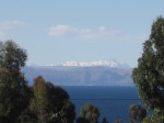
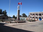
Puno is the second most touristed city in Peru, after Cuzco.  The interesting thing is that most people (including myself) do not actually spend that much time in the city of Puno itself, but rather, use it as a launching pad to visit the islands on Lake Titicaca, the highest navigable  lake in the world (3840 meters). The entire Puno/Lake Titicaca area is FREEZING right now as well.  I finally had a reason to take out my down jacket!


So after spending a chilly night in Puno, I got on a local boat to head out to the islands.  They have organized tours available to all of the islands, especially the floating islands of Uros (which are made out of reeds and really are floating), but I had heard negative things about these tours and opted to figure it out on my own and force myself to use my newly revised Spanish.  I am so glad that I did as I got to see so much more than I would have if I had had to stick next to a tour guide and stay on their timetable and explore what THEY thought was interesting, instead of what I thought was interesting.  It was an awesome experience!


THE FLOATING ISLANDS OF UROS:

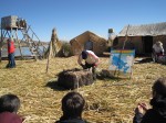
]The first stop that the boat made was to the floating islands of Uros.  Interesting enough, the 40 minute stop was more than enough time to learn about them and move on.

The floating islands of Uros have been in existence for over 900 years. The inhabitants have to constantly add more reeds to the top layer in order to replenish the rotting reeds below.


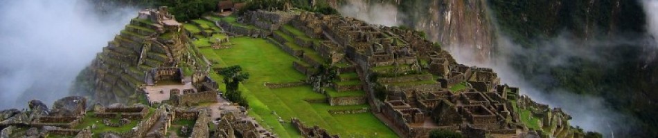
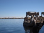
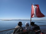
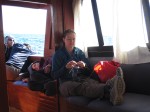
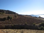
Start of boat ride across Lake Titicaca to the floating islands of Uros, and the "knitting islands" of Amantani and Taquille.


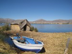
A first glimpse of the floating islands of Uros


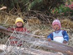
Waiting for an informative session about the history and construction of the floating islands.


HOMESTAY ON THE ISLAND OF AMANTANI

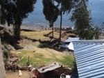
After the floating islands, we hopped back on the same boat to head to the island of Amantani for the night.  The island has a system of tourism in which the 4,000 inhabitants (made of up 95 different communities) share homestays of foreigners according to a system that ensures no family has a guest more than once a month.  The islanders live on subsistence farming, namely 40 different varieties of potatoes.


The homestays are the only time the people of Amantani actually earn money, with everything else on the island obtained through trade.

The Señora of our homestay on the island of Amantani came to meet us... you can she her spinning wool as we walk along the beach back to her home.

The women on the island of Amantani knit beautiful hats, while it is the men who sew and embroider the clothes the women wear.

Room at homestay on Amantani. The luxury of solar panels meant light at night!


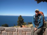
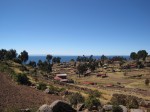
Incan ruins: Entrance to the top of PachaMama, the highest point on the island of Amantani.

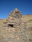
Random building on the island of Amantani... geometry is everywhere!


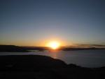
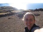
Before dinner with the 6 french speaking travelers I became friends with, we climbed to the top of the island to see the sunset.

Stealing a few moments by myself before the sunset.


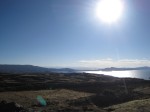
Sunset over Lake Titicaca. Island of Amantani


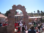
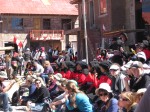
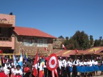
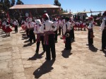
INDEPENDENCE DAY ON THE ISLAND OF TAQUILLE

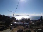
The next morning, we got up and onto another boat to head to the island of Taquille.

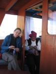
Inspired by all of the knitting and weaving around me, I find some time to knit on the boat ride from Amantani to Taquille.

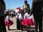
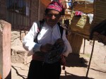
Taquille is interesting.  On this island, the men are known more for their knitting than the women.  The men wear red or red/white hats that they knit themselves in order to indicate their “married” or “single” status.

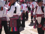
Traditional dress on the island of Taquille. They swear they dress this way everyday, not just on Independence Day.


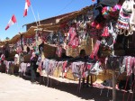
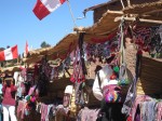
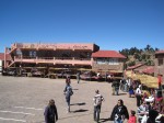
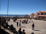
The women weave intricate belts that they give their husbands.  The women also spin wool.  The island centers around the plaza de armas, where they sell amazing textiles.


CULTURE OF KNITTING AND WEAVING ON THE ISLANDS OF LAKE TITICACA


The belts in particular have very interesting design, many of which are geometric.

Amantani belt

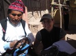
I spent quite a bit of time sitting with the man who sold me the belt afterwards.  He seemed genuinely excited that someone wanted to know what they symbols actually meant to the culture and people of Taquille.  It was definitely a highlight of the journey so far!


One symbol the appears over and over again is the "6 suyos". According the man I bought the belt from, these are 6 crops, or elements of sustenance on the island, such as quinoa, corn, fish, etc. According to the internet, it is the 6 communities on the island. I guess I will have to do more research!

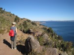
We spent the rest of the day exploring the island and hiking.  It was so beautiful!

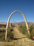
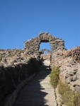
Went for a nice little hike around the island of Taquille and came across many arches. The red flowers above are used to dye the wool they knit with on the island.


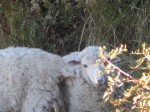
Sheep on Taquille= wool= knitting. 🙂


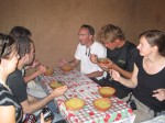
EXCHANGE OF IDEAS AND TECHNIQUES

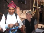
The next day, we took a boat back to Puno.  Doing as I always do when travelling, I took out my knitting.  This caused quite a bit of excitement!  The technique the men of Taquille use is completely different thanwhat I use.  It was lots of fun, showing each other not only  how we knit (Me: holding the wool in my right hand. Them: twisting the wool around their neck and knitting from the opposite side of the fabric), but also what we knit.  I was working on a pair of socks, which was really interesting to them.  The designs and color work in their hats is so intricate, I can hardly hope to learn how to do it!

I ended up knitting with this man from the Island of Taquille most of the boat ride back to Puno. So interesting to compare techniques and patterns!


Overall, the three days I spent on the islands were absolutely amazing and I learned to much!  Truly, the perfect place for me to go!

More from Cuzco later!

Ms. Bruck

Puno, Lake Titicaca and the floating islands of Uros and the “knitting islands” of Amantani and Taquille

In Puno, on the shores of Lake Titicaca for the night and heading to Cuzco tomorrow.  There were so many pictures to upload from my recent three days and two nights on the islands of Lake Titicaca, that I am hoping a slideshow with captions will help to translate the amazing experience much better than I ever could in writing.   🙂


Note: I realize now that the slideshow does not show the captions that I wrote for each picture.  I added the gallery below, which does seem to have most of the captions, but out of order.  Since I´ve been at the computer for almost 3 hours now (it takes awhile to upload!) I´m going to leave it and try to fix it in a few days.  Regardless, I hope you can piece together the story in the photos until I do!


Ms. Bruck


This slideshow requires JavaScript.


Almost time to say goodbye to my homestay…and trekking in the Colca Canyon.

Today was my last day in Arequipa.  I spent it being a complete tourist, taking the red hop on/ hop off bus tour around Peru`s second largest city.  Yep, they have those here too.  Just as in other city´s I´ve been, not all of the stops pertained to my particular interests, but it was a good way to see a lot of the city in a short amount of time.  I will be sad to say goodbye to Lucy and Marcela and also, Cet and Milagros, my two Spanish teachers while I have been here.  Thank you all for making me feel welcome and giving me the confidence needed to go forth with my (previously rusty) Spanish skills!

Outside of my homestay with Spanish Teacher, Cet, and homestay "mom" Lucy

Outside of my homestay with Spanish Teacher, Cet, and homestay "mom" Lucy

Outside of my homestay with Spanish Teacher, Milagros, and homestay "mom" Lucy

Me, Milagros, Lucy

Spanish Teacher Milagros

Spanish Teacher Cet

COLCA CANYON AND PRE-INCAN TERRACES:

Taking with me only what I needed and leaving most of my belongings at my homestay, I went to the nearby Colca Canyon this weekend.  The Canyon is famous for its Pre-Incan terraces, 70% of which are still in use farming today, a bluff known as the “Cruz del Condor,” where one can see Condors with wingspans of up to 3 meters long soaring above you, and Peru´s second deepest canyon ( 4,160 meters, which is just how high kids….).  I think that is about twice as  deep as the Grand Canyon in Arizona.  It was absolutely breathtaking.

Pre Ican Terrace farms still in use: Colca Canyon, Peru

You can see the terraces below still in use.  If you look closely, way up high in the mountains, there are lines across the hillside…. these are Pre-Incan and Incan terraces farms no longer in use.  What a crazy example of  “slope.”  It amazes me to think that people actually farmed on terrain that steep!


The Condors were pretty breathtaking to watch.  Photos and pictures can do justice to none of this trip, but I will try to post a short video I took of the Condors in a little bit.

Our trek started up at just over 3300 meters.  The altitude here is amazing!  We actually drove up and over the mountains at 4900 meters (16,079 ft!)  just to get to the Colca Canyon.  From our starting point, we descended over 1200 meters to the valley and river below.   I know from backpacking that downhill is ultimately harder on your body than uphill!  Three and a half hours later, we arrived at the bottom, gratefully for some shade.  Despite it being the middle of winter here and freezing as soon as the sun sets, it is warm enough to give me quite a sun burn during the day!

After reaching the bottom of the Canyon and crossing the river, which ultimately drains into the Pacific Ocean, we hiked up to a small village (50 people), where we had lunch.  The hike after lunch, which meandered through the villages and followed the water irrigation system/aqueducts was my favorite part of the hike.  There were a few hills, but overall, it was fairly relaxing.  I wish I had taken more pictures of the acquaducts as they were quite simple yet amazing.


Our guide, Cariña, giving details about a local shrine, which pays respects to both the local customs (the moutains) and Spanish/Colonial Influences

We arrived at the Oasis, where we would spend the night, about 40 minutes or so after dark.  A piece of advice… always keep your headlamp someplace where it is easy to locate in your backpack!  I never think I am going to need it at the beginning of the day when I pack my back, but it´s amazing how many times I´ve had to look for it, after it has already gotten dark!

The next morning, we woke up at 4:30am to start the 1,010 meter hike back up the hill to the village of Cabanaconde, where we would get breakfast and the bus back to Arequipa.  This climb was no joke!  It was strenuous enough that no less than 15 people chose to hire mules to ride back up to the top!  I cannot even imagine how sore I will be after my 5 day trek to Choquequirao later in the trip, as I was plenty sore after this short, 2 day trek!  It looks like Ms. Bruck needs to start hiking, backpacking, running and climbing more in general again!

Back up at the top of the canyon and ready for breakfast!

People still dress very traditionally in this part of the country.  I am very shy about taking photos of people, but I do have these three.  Aren´t the textiles beautiful?  These women are not just dressed up to sell their wares to tourists!  We actually saw virtually all of the women throughout the valley dressed in the same traditional manner.  It is awesome to know that at least some parts of cultures prevail once exposed to the outside world.


Ms. Bruck